You should spend about 20 minutes on this task.
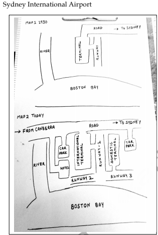
The following maps show the changes that have taken place in Sydney International Airport since 1930. Summarise the information by selecting and reporting the main features and make comparisons where relevant.
Write at least 150 words.

Model Answer
The given maps allow us to see changes in Sydney International Airport, over a period of 85 years. It can be seen that radical changes have taken place in the airport over the given period of time.
In 1930, the airport was relatively small and consisted of one terminal and one runway, which can be seen in the centre of the layout between the Boston Bay towards the south and the road to Sydney towards the north. Towards the west of the terminal, a river flowing from the north to south can be seen merging into the Boston Bay.
The second map shows the present Sydney International Airport. The road on the north has been extended towards the west for traffic coming from Canberra. The terminal has now become the International Terminal. A Domestic Terminal has been constructed towards the east with the runway 1 between both terminals. Two more runways have been added towards the south between the terminals and the Boston Bay. Two car parks have been made, one near each terminal. A hotel has also been constructed between the International Terminal and the river.
Overall, the Sydney International Airport has witnessed a major development in a period of eight and a half decades.